Monsoon III (4K)
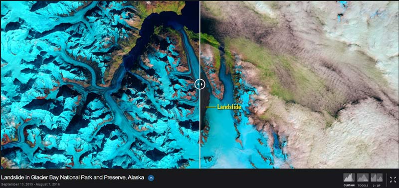
La Nasa propone immagini da satellite del progetto Image of Change improntate ai cambiamenti ambientali avvenuti in vari periodi. Le localizzazioni si possono visualizzare su mappa (per l’Italia c’è solo una criptica immagine relativa all’inquinamento luminoso di Milano) oppure tramite gallery fotografica (eventulmente filtrandole per argomento: all, cities, ice…). Ci sono tre modi per visualizzare le foto (curtain, toggle, 2-up), si può approfondire l’argomento e scaricare le immagini.
This was easily one of the most exciting and challenging projects I’ve ever worked on. We headed to the Big Island for just 3 nights with the goal of trying to capture the stars above the lava entering the ocean. With such a short window to capture what we traveled for it was pretty critical that we didn’t miss a single opportunity.
Head over to the Macphun blog to see the full trip write-up and a behind the scenes video. macphun.com/blog/lavalapse
Special thanks to Sigma and Macphun for coming together to make this happen. Extra thanks to Mark Jacobs from MacPhun for all his help, making the trek with me and grabbing some awesome BTS footage along the way.
I hope everyone enjoys the timelapse!
jackfusco.com | jwfusco@gmail.com
")
The Enhanced Thematic Mapper Plus (ETM+) on the Landsat 7 satellite acquired this natural-color image of snow in North Africa on December 19, 2016. This scene is south of the city of Bouarfa and southwest of Ain Sefra, which saw its first snowfall in 37 years.
(via Earth Observatory)